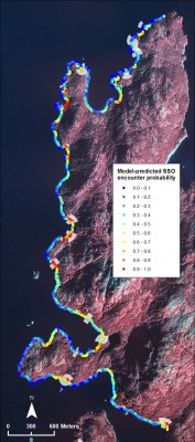
Oil from the 1989 Exxon Valdez oil spill of 10.8 million gallons of Alaska North Slope (ANS) crude oil has persisted along shorelines for 20 years, as both surface and subsurface oil residues. Surface and subsurface oil may be causing on-going exposure and potential harm to living organisms, wilderness areas, recreational activities, and subsistence users in Prince William Sound and the Gulf of Alaska. Trustees needed to quantify and map the relative amount of subsurface to better understand impacts and prioritize shorelines for different remediation methods.
 RPI developed a series of advanced spatially-explicit, machine-learning models based on field data collected between 2001 and 2008. These data allowed us to identify a number of geomorphologic and hydrologic factors that have contributed to the persistence of subsurface oil two decades after the spill, and to provide specific estimates of location and quantity of remaining subsurface oil. Using different screening criteria, the model results can be used to understand lingering oil distribution and prioritize shoreline for remediation.
